Transportation

93 readers
1 users here now

Discussion of all things transportation (road planning, mass transit, cycling). This forum is implicitly focused on the Atlanta region, but any transportation-related posts are considered on-topic.

founded 1 year ago
MODERATORS
1


It's rare that MARTA has changed the realtime train API. And this is definitely the biggest change I've seen in the decade I've been using it. A longstanding complaint I have gotten while maintaining marta.io is that it only includes active trips, or moving trains and their destination. On Friday I noticed that their new train API endpoint includes future, scheduled trips. I added some quick styling for them (faded pills, calendar icons), and am excited to give it a whirl next week!

2
3


Response to questions/complaints about the planned Beltline light rail

4


In 2022, 38 people lost their lives while walking inside Atlanta city limits. That’s 23% more than in 2021, and a full 52% more than in 2020. The rise marks a continued upward trend that started in 2018 in a city whose overall traffic fatality rates are already high compared with similarly sized cities.

More than two-thirds of all Atlanta’s pedestrian fatalities occurred in predominantly Black neighborhoods, places with fewer features like sidewalks, crosswalks, and bike lanes that provide basic safety for pedestrians and people outside of cars.

5
6


cross-posted from: https://yall.theatl.social/post/830010

From Decaturish:

We accept letters to the editor. Letters to the editor are opinions of the authors of the letter, not Decaturish.com. Everyone has an equal opportunity to submit a letter to the editor. So if you read something here and don’t like it, don’t jump on our case. Write a letter of your own. All letters must […]

7


cross-posted from: https://yall.theatl.social/post/824731

From Decaturish:

Atlanta, GA — There were 38 pedestrian deaths in Atlanta in 2022, a 23 percent increase over the previous year, a report by an advocacy group says. Propel ATL, which advocates for cyclists and pedestrians, said, “More than two-thirds of all Atlanta’s pedestrian fatalities (25 out of 38) occurred in predominantly Black neighborhoods, places with fewer […]

8


Even in our 'walkable' city, kids are still getting killed crossing the street.

9


DeKalb County is soliciting input on the master plan for trails and greenways. This page has links to a survey as well as to an interactive map where you can suggest trail destinations or flag problems.

10


If you ride MARTA buses regularly, I'm slowly trying to get a UX put together that's usable at https://martalith.fly.dev. Things like:

  • "I get on the same buses every day (at 2-3 stops) and just want to see my bus situation clearly/quickly"
  • "I transfer at X station regularly and want to know the status of Y/Z routes for that station"

I've tried to build this in the past, and the bus data either confused me or didn't seem usable. But MARTA recently added realtime bus positions + trip update endpoints, and early tests are looking more positive! When I can find an excuse to ride buses, I'm testing things out, but it's slow-going.

I try to remember to put updates here when things change https://fosstodon.org/@jakswa

11


Hey Neighbors (all over the metro).

The Atlanta Regional Commission is working on an update of the Metropolitan Transportation Plan. They are currently in the public input phase.

The survey takes about 15 minutes and asks about all sorts of priorities for the future of transportation in the Atlanta Region.

Direct Survey Link

12
13
14


cross-posted from: https://yall.theatl.social/post/1816

Atlanta is set to receive $25 million from the federal government to ramp up construction of Beltline trails on the northeast side of the city.

The funds mark the largest federal grant in Beltline history and will go toward expanding more than 2 miles of trails between Armour/Ottley and Lindbergh areas. The additions will be the first time the Beltline will connect to a MARTA station — which will be at Lindbergh Center.

15


Councilmember Jason Dozier is sponsoring a set of zoning papers for the BeltLine overlay districts to disallow new car-oriented businesses like gas stations, drive thrus, and service stations, and to eliminate the mandated minimum number of parking spaces for new developments.

16
17


OpenStreetMap is a internet project that distributes free geographical data to the world. It relies on a community of volunteer editors to keep the information up to date.

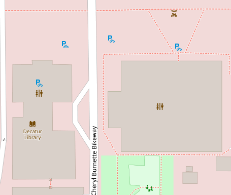
One benefit of OSM is that it allows groups of editors to decide what matters to them and add the features to the map, rather than hoping that some corporation decides that a feature is profitable enough. For instance, OSM shows the location of bike racks near the Decatur Library, and properly notes that the paths through Scott Park are foot-paths.

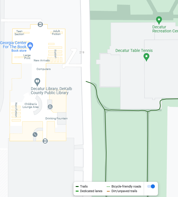
In contrast, the Google Maps "bicycle" layer does not include bike racks and highlights those footpaths as though they are appropriate for biking (despite being right next to a building with multiple doorways and sharp turns with no visibility)

Still, OSM is not perfect -- I had no problem finding information that was right in Google Maps that was wrong in OSM (and vice versa). I figure that Google benefits either from web-scraping and more automation, or perhaps from more user feedback. OSM requires more effort, but this also means it gives us greater input over it's content (and has greater curation to avoid idiotic AI stuff). I signed up and made some edits myself -- OSM has a good editing interface and a good walkthrough tutorial.

But I think the most important aspect is that OSM is free (as in speech), which means anybody can copy it and no single entity can just hide or discard all the data when it no longer fits in their business strategy.

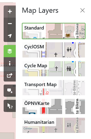
I found two cycling based projects based off of OSM: https://www.opencyclemap.org/ and https://www.cyclosm.org/. These are also shown in the "Layers" on OSM:

The maps displays are pretty complex, and I'm not sure if there's an easy app for planning your route using these data.

I also found a project focused on wheelchair accessibility when I looked at the "history" view and saw that someone has been editing the decatur map from https://wheelmap.org/.

So the end question is whether this map data can end up being helpful to both personal transportation and transportation advocacy in Atlanta. I'd love to hear any thoughts on this topic.