1
De-Bayered L-MastCam mosaic - Assembled in MS-ICE
NASA/JPL-Caltech/MSSS/fredk

A lemmy community for scientific discussion of the Curiosity Rover and Mars Science Laboratory.
De-Bayered L-MastCam mosaic - Assembled in MS-ICE
NASA/JPL-Caltech/MSSS/fredk
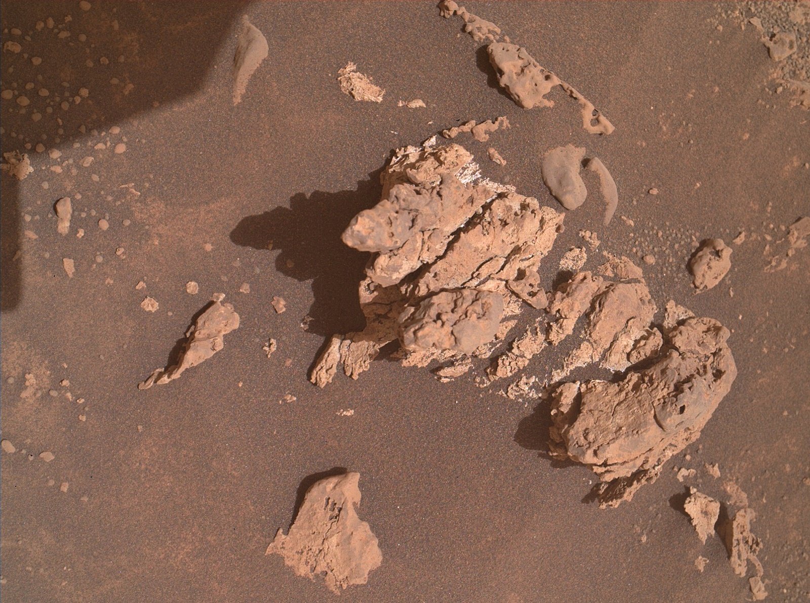
Curiosity acquired this image using its Mars Hand Lens Imager (MAHLI), located on the turret at the end of the rover's robotic arm, during September 17, 2024 (Sol 4307). The camera focus motor count (returned with the image) can be used to calculate the camera standoff distance (camera lens to the target). In this case the standoff was close to 25 centimeters (~10 inches). This provides an image scale of ~95 micrometers per image pixel, or a scene width of ~15 centimeters (~6 inches). Image Credits: NASA/JPL-Caltech/MSSS.
Awaiting drive data and the location. While we're waiting for those details, I have assembled a selection of the post drive L-NavCam images into a small mosaic, clearly showing the low ridge in front of the rover that was discussed in the last mission update.
The reasons for the drive on sol 4306 are detailed in this mission update https://science.nasa.gov/blog/sols-4304-4006-12-years-42-drill-holes-and-now-1-million-chemcam-shots/
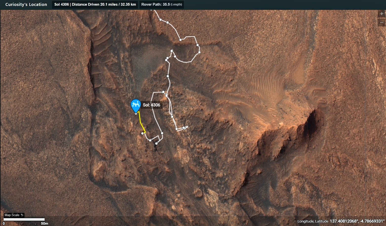
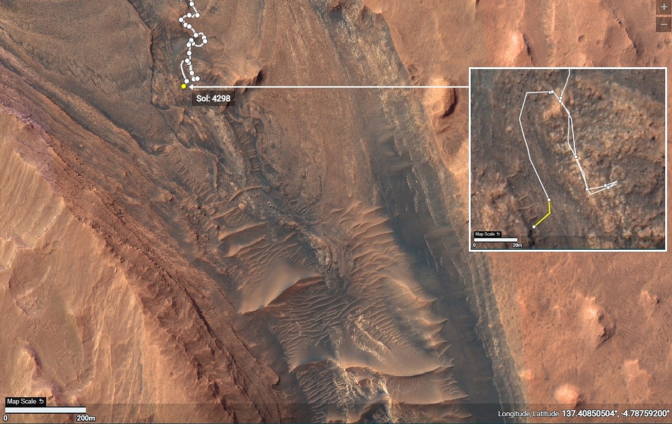
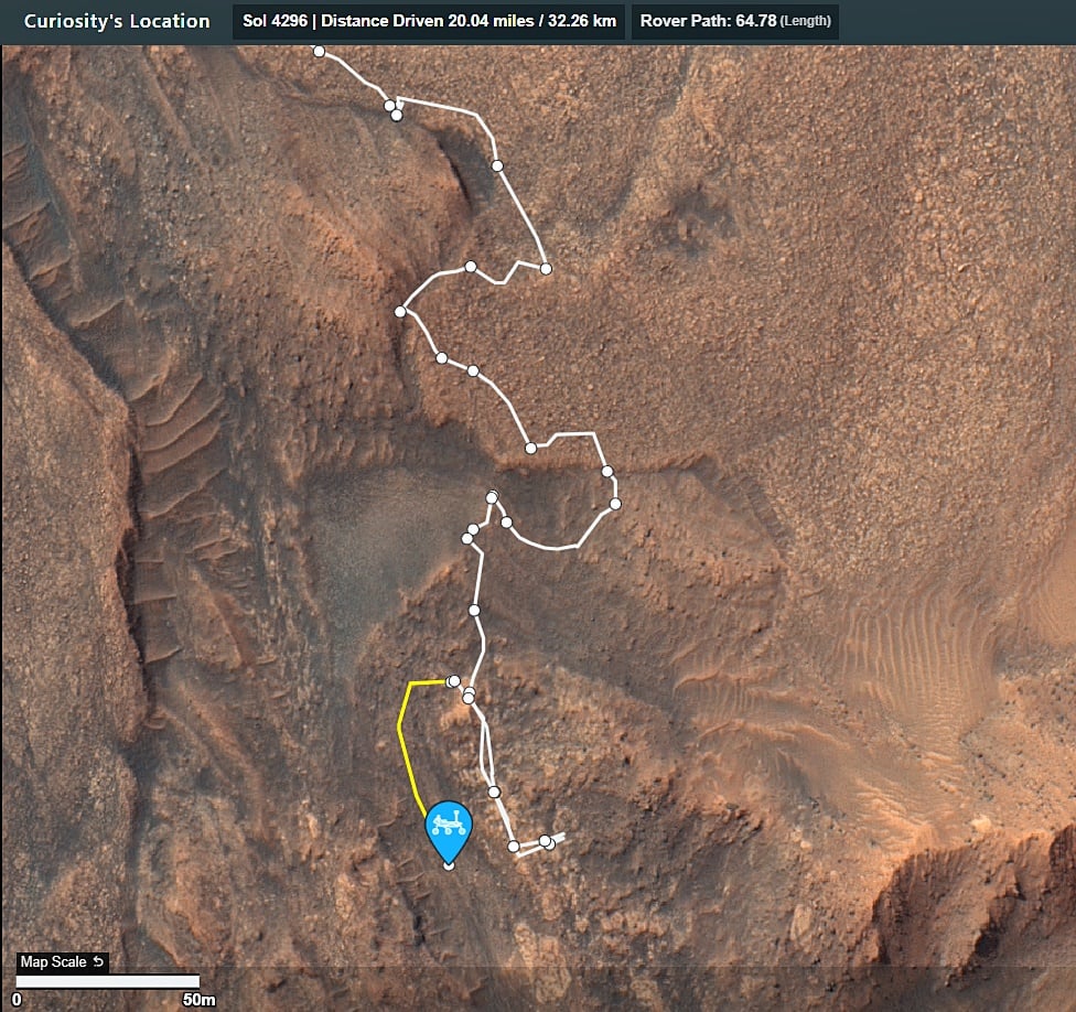
This drive was downslope to site 108.2792. The new site is 4.31 meters (14.14 ft) lower than the previous site 108.2528. The rover is pointing towards the Southwest (228.34°) The end-of-drive image is from the rover left-side navigation camera. Credits: NASA/JPL-Caltech

This data is updated and released by JPL via it's JSON URL's after each drive.
I import the JSON data into this table to make it easier to digest
If anyone wants to check the JSON, you can find it on this URL. https://mars.nasa.gov/mmgis-maps/MSL/Layers/json/MSL_waypoints.json

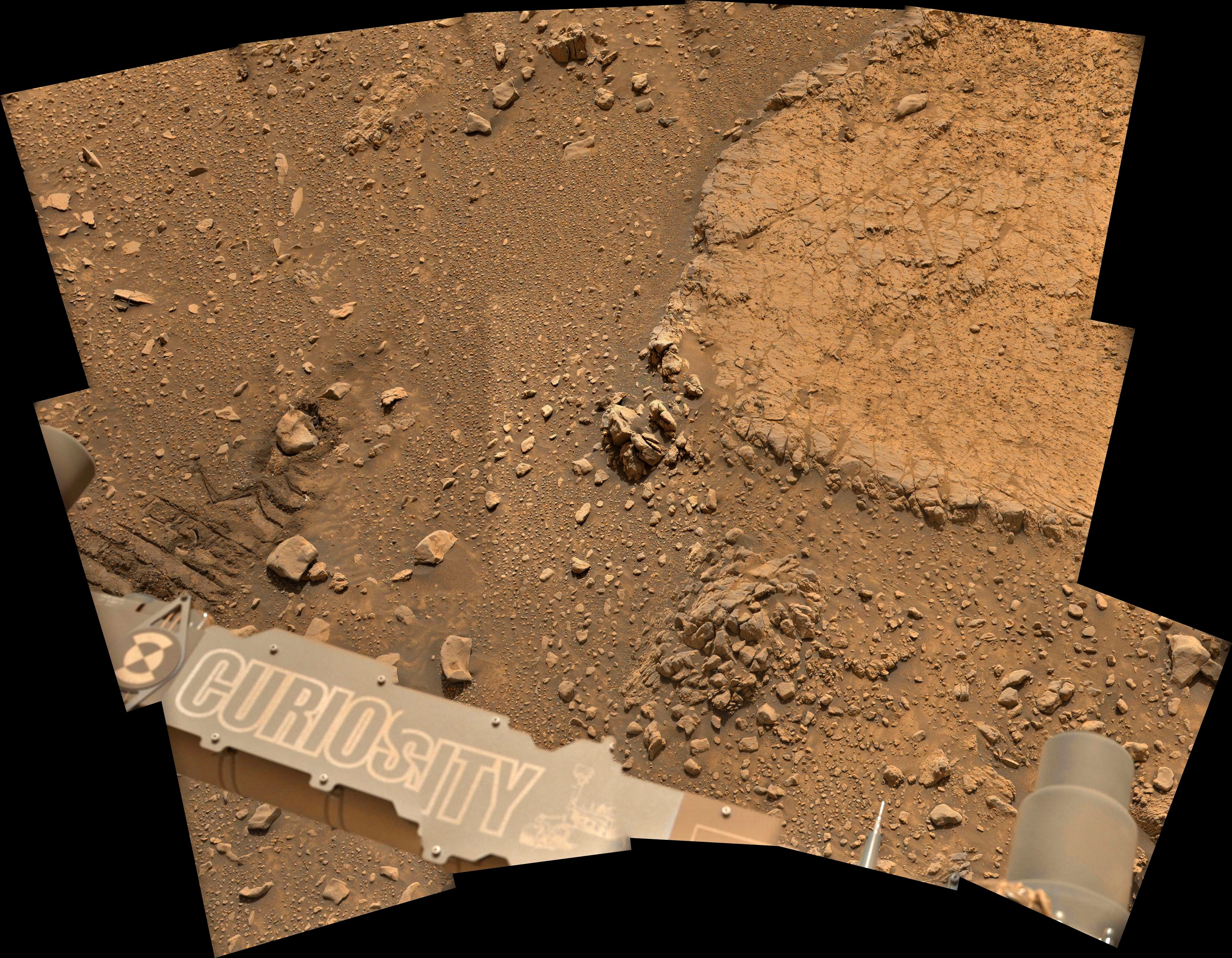
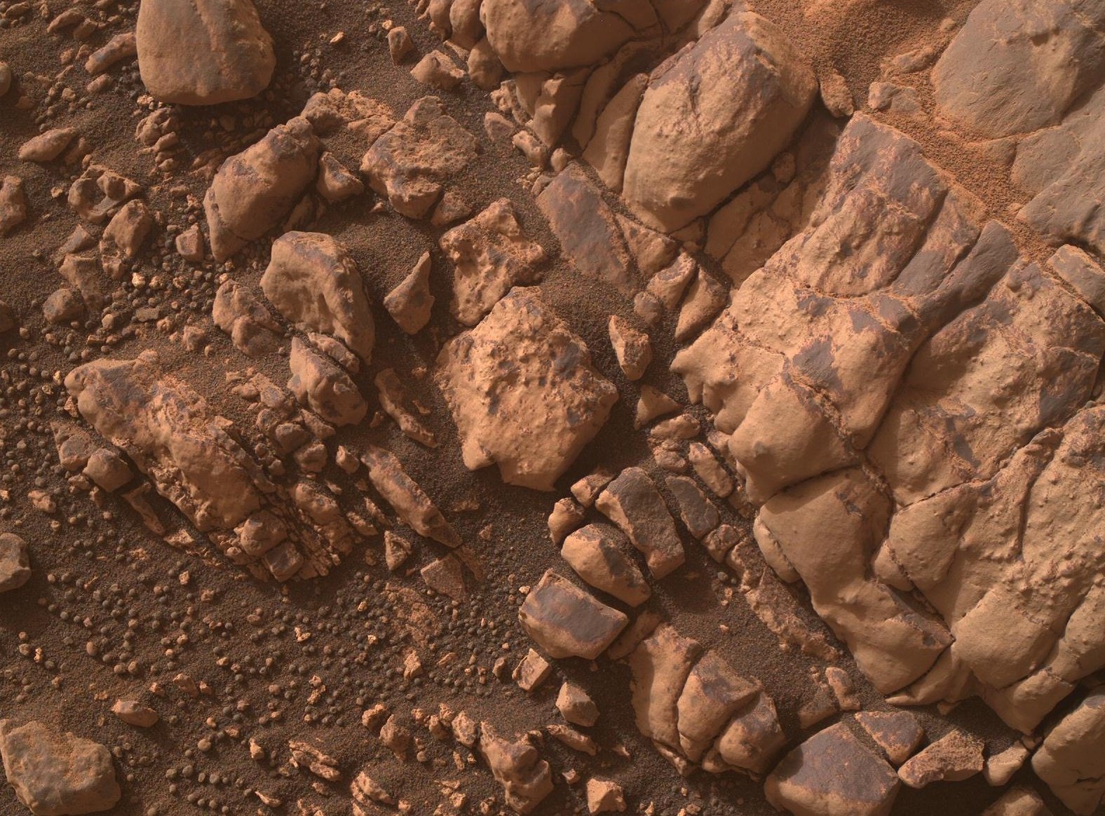
L-MastCam de-Bayered mosaic, roughly assembled in MS-ICE using 15 overlapping frames. It features the terrain accessible to the rover's robotic arm
credits: NASA/JPL-Caltech/fredk

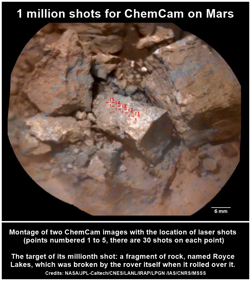
On Monday 19th August 2024, the millionth laser shot on Mars by ChemCam, one of the instruments on NASA's Curiosity rover, was planned by French teams at CNES.
Two days later, on Wednesday August 21, at around 8.20 pm French time, the millionth ChemCam shot was fired at Mars. This was Sol 4281, the 4281st Martian day of the mission. The data were received on Thursday August 22nd for analysis by the American team.
The target of this millionth shot: a fragment of rock, named Royce Lakes, which was broken by the rover itself when it rolled over it. The whitish interior of the rock, contrasting with the orange-red appearance of the Martian surface, immediately caught the eye of the scientists.
Other recent observations were decisive in the choice of this target: sulfur crystals were discovered in a valley on Mount Sharp, which the rover is currently climbing. Scientists are wondering whether this rock will have the same properties...
As usual, several measurement points were made on this target, 5 in all. And on each point, several shots: 30 in all. Each shot provides new information and enriches the Martian composition database. This millionth shot represented the 11th shot on the 4th point.
ChemCam's mission is to measure the chemical composition and image the rocks and soil on the surface of Mars.
The French hardware contribution to ChemCam was built on a partnership between CNES, CNRS-INSU, several universities (Toulouse, Bordeaux, Paris, Lorraine, Lyon) and CEA. ChemCam is under the joint scientific responsibility of Los Alamos National Laboratory (LANL) in New Mexico (USA), and the Institut de Recherche en Astrophysique et Planétologie (IRAP, France) of the Observatoire Midi-Pyrénées in Toulouse. CNES plays a major role in its operational and technical operation, in conjunction with the Jet Propulsion Laboratory (JPL, USA) and research laboratories on both sides of the Atlantic.
Read the full news release that includes additional images, and the spectra measured on this target on this link: https://cnes.fr/en/news/1-million-shots-chemcam-mars
Credits: NASA/JPL-Caltech/CNES/LANL/IRAP/LPGN/IAS/CNRS/MSSS
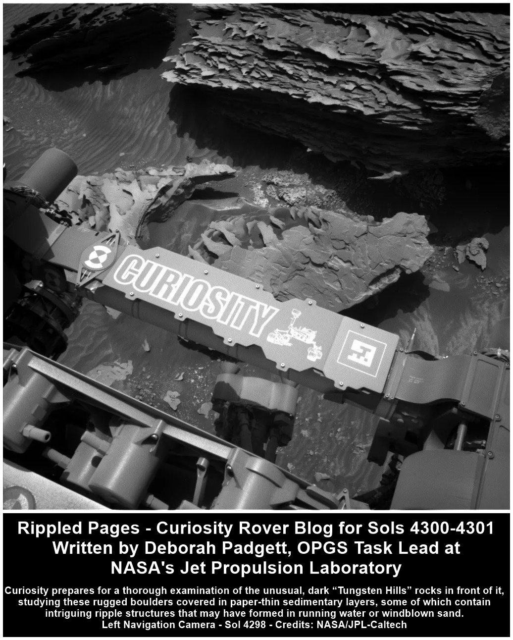
Rippled Pages - Curiosity Rover Blog for Sols 4300-4301
Earth planning date: Monday, Sept. 9, 2024
With today’s plan, Curiosity completes its most southerly planned exploration of the Gediz Vallis channel. From here, our rover will head north and climb out of the channel to explore terrain to the west. Our planned drive to the “Tungsten Hills” rocks, named for a famous mining district near Bishop, California, completed successfully over the weekend, placing a pile of unusual dark rocks within our workspace. Curiosity is currently in the “Bishop” quadrangle on our map, so all targets in this area of Mount Sharp are named after places in the Sierra Nevada and Owens Valley of California. On sols 4300-4301, Curiosity will perform a thorough examination of these rugged boulders, which are covered in paper-thin sedimentary layers like the pages of a book (see image). Some layers have intriguing ripple structures that may have formed in running water or windblown sand. These features are the prime targets for contact science and remote observation at this location.
On Sol 4300, Curiosity will obtain ChemCam laser spectra and Mastcam imagery on a part of the closest plate-like rock called “Bonita Flat,” after a high valley above the southern Kern River canyon in Sequoia National Forest. ChemCam will also obtain telescopic views of a section of the Gediz Vallis channel banks with its RMI camera. Mastcam will take a mosaic of the upper reaches of the channel, then turn its cameras on the interesting bedrock of “Coffeepot Canyon,” honoring a ravine along the precipitous East Fork of the Kaweah River canyon in Sequoia National Park, unfortunately now engulfed in a huge wildfire.
The first science block ends with atmospheric observations, including a dust-devil movie, supra-horizon cloud imaging, and Mastcam measurement of dust in the air across the crater. Curiosity will then use its arm to brush the dust from the closest block in an area dubbed “Pond Lily Lake,” for a petite meadow lake atop the canyon wall of the San Joaquin River, downstream of Devil’s Postpile National Monument. This cleared spot will then be imaged by MAHLI and Mastcam, and its composition will be measured by APXS spectroscopy. MAHLI will perform an intricate “dog’s eye” maneuver to obtain detailed images of ripples in “Window Cliffs,” named after sheer walls above the spectacular fault-controlled Kern River canyon west of 14,505-foot Mount Whitney, the tallest peak in the lower 48 states. MAHLI wraps up a very full day of work by imaging the scalloped edge of the largest nearby block, dubbed “Boneyard Meadow” for a wetland in the western Sierra foothills where many sheep sadly perished due to a late spring snowstorm in 1877.
Early on sol 4301, Curiosity will use Mastcam to thoroughly document the Tungsten Hills in pre-sunrise morning light. Later in the day, a second science block starts with ChemCam spectroscopy and Mastcam imagery of “Castle Domes,” honoring the granite domes of Castle Valley, acclaimed as some of the most beautiful mountain scenery in Kings Canyon National Park. ChemCam RMI will perform telescopic observations of the channel floor. Mastcam will look for possible sulfur rocks at the base of the Tungsten Hills blocks in a target named “Hummingbird Lake,” for an alpine lake at 10,000 feet between Bloody and Lundy Canyons near Mono Lake. This science block of the plan ends with Navcam deck monitoring, dust measurement, and a large dust-devil survey. Curiosity will then drive north, taking a MARDI “sidewalk” video of the terrain under the rover during the drive.
Written by Deborah Padgett, OPGS Task Lead at NASA's Jet Propulsion Laboratory
Source for this blog and the archive of all blogs (with all the links and the original raw images etc): https://science.nasa.gov/blog/sols-4300-4301-rippled-pages/
These blog updates are provided by self-selected Mars Science Laboratory mission team members who love to share what Curiosity is doing with the public.
Dates of planned rover activities described in these reports are subject to change due to a variety of factors related to the Martian environment, communication relays and rover status.
Image credits: NASA/JPL-Caltech
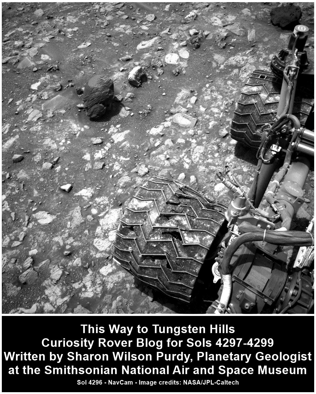
This Way to Tungsten Hills - Curiosity Rover Blog for Sols 4297-4299
Earth planning date: Friday, Sept. 6, 2024
Curiosity completed an impressive 60-meter drive (about 197 feet) across the channel floor within Gediz Vallis and parked along the edge of a shallow linear depression. Just about 20 meters (66 feet) away, an intriguing dark, textured rock named “Tungsten Hills” is the destination for our weekend drive and our contact science on Monday. Today I served as the “Keeper of the Plan” for the Geology theme group and worked with the science team to compile a variety of contact science and targeted science in this three-sol plan.
Contact science in our immediate workspace includes a joint effort by MAHLI and APXS to characterize a gray rock with two targets named “Big Baldy” and “Big Bird Lake.” ChemCam focused its Laser Induced Breakdown Spectroscopy (LIBS) instrument on a rock with a reddish coating, “Purple Creek,” and a light-toned rock, “Garlic Meadow,” to determine their chemical composition. ChemCam included a long distance RMI image of the yardang unit that caps Mount Sharp as well as a standard post-drive AEGIS activity, which allows autonomous target selection for upcoming geochemical spectrometry.
The Mastcam team assembled several beautiful mosaics to document Curiosity’s surroundings. One mosaic will extend the imaging of the current workspace and is planned at dusk to take advantage of the diffuse lighting. Two separate mosaics, one of which is in stereo, will characterize the floor of the depression in front of Tungsten Hills to investigate the exposed light rocks and document depositional processes. Finally, a stereo mosaic will image Tungsten Hills and the surrounding terrain in advance of our approach over the weekend.
With the weekend plan in place the science team will now patiently wait for data to be returned and for planning to resume on Monday!
Written by Sharon Wilson Purdy, Planetary Geologist at the Smithsonian National Air and Space Museum
Source for this blog and the archive of all blogs (with all the links and the original raw images etc): https://science.nasa.gov/blog/sols-4297-4299-this-way-to-tungsten-hills/
These blog updates are provided by self-selected Mars Science Laboratory mission team members who love to share what Curiosity is doing with the public.
Dates of planned rover activities described in these reports are subject to change due to a variety of factors related to the Martian environment, communication relays and rover status.
Image credits: NASA/JPL-Caltech
10 overlapping images NASA/JPL-Caltech/MSSS/fredk

Sol 4298: Front Hazard Avoidance Camera (Front Hazcam) after a drive to site 108.2162,
Waiting data for the drive (at this time)

Close up - MAHLI camera standoff ~25 cm.
Image scale ~95 micrometers per pixel, or a scene width of ~15 cm (6 inches)
Image rotated to closer match those from the rover's other cameras
NASA/JPL-Caltech/MSSS
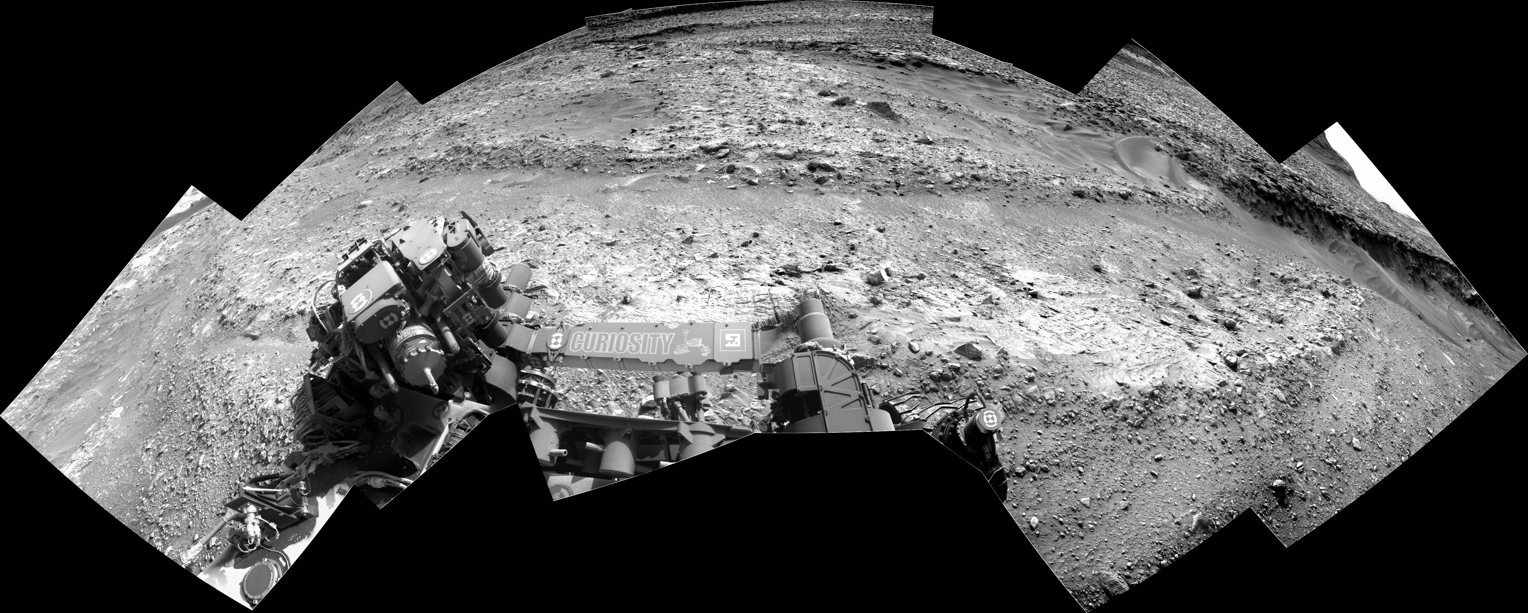
Assembled from 10 overlapping Bayer reconstructed L-MastCam subframe images. For those who missed the earlier mission update, the L-MastCam has a stuck filter wheel, so about half of the full frame images are now obscured by the jammed filter wheel. Luckily the team can command sub-frame images, but they need more images to build the mosaics. You'll also note that the images have slightly darker borders which MS-ICE sometimes fails to blend during assembly, but it's great we can still get some great images from the camera. NASA/JPL-Caltech/MSSS/fredk

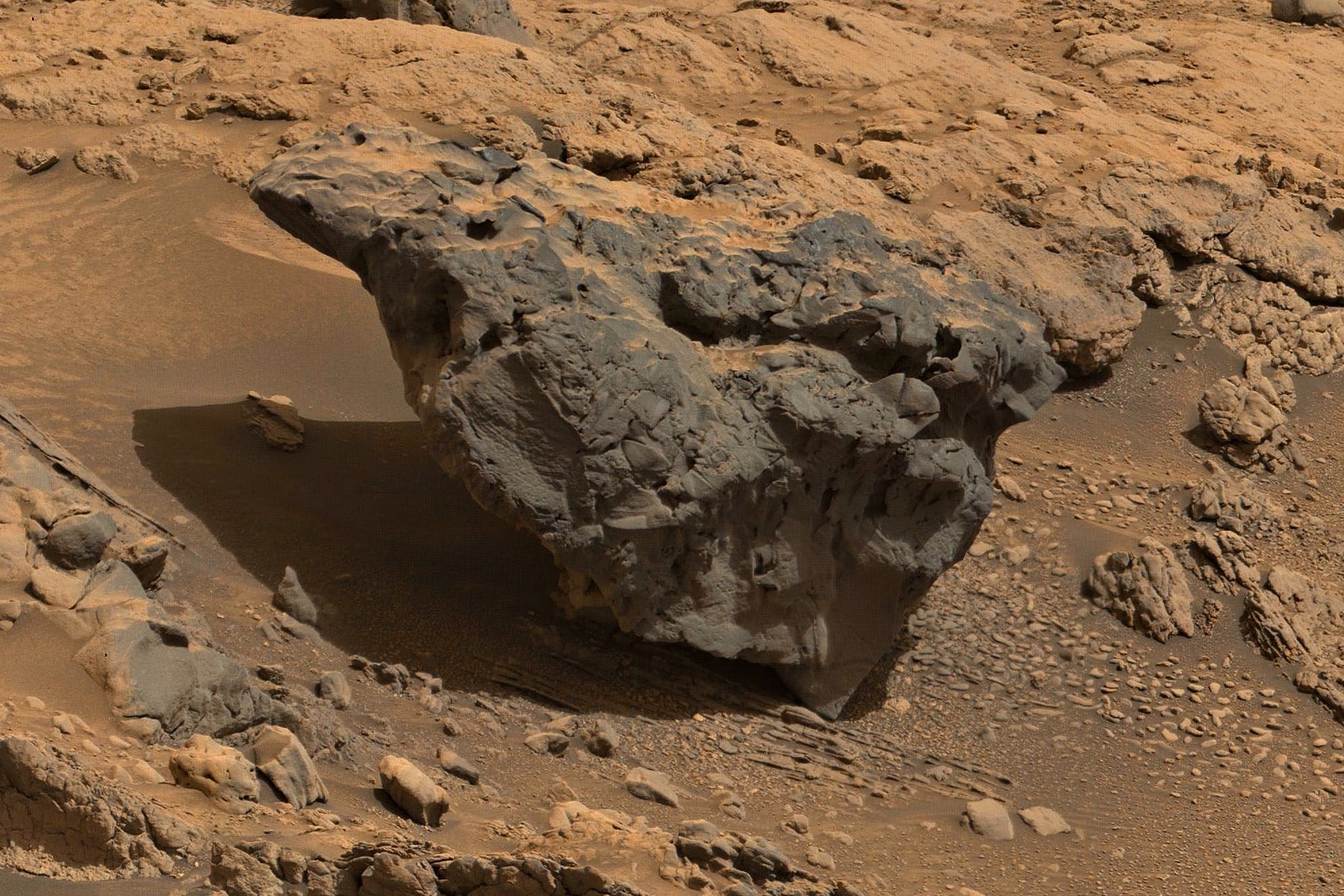
One of many darker float rocks just beyond the rover's workspace. This mosaic was assembled using MS-ICE and then cropped from a larger mosaic. The crop is made up of around 6 overlapping Bayer-reconstructed R-MastCam full frames. NASA/JPL-Caltech/MSSS/fredk
After a walkabout studying the local terrain, Curiosity heads back South along its notional path
When the rover reaches a new location the team often commands a MastCam mosaic of the terrain in the direction of the rover's notional path (towards its next waypoint). I believe this is likely one of those occasions.
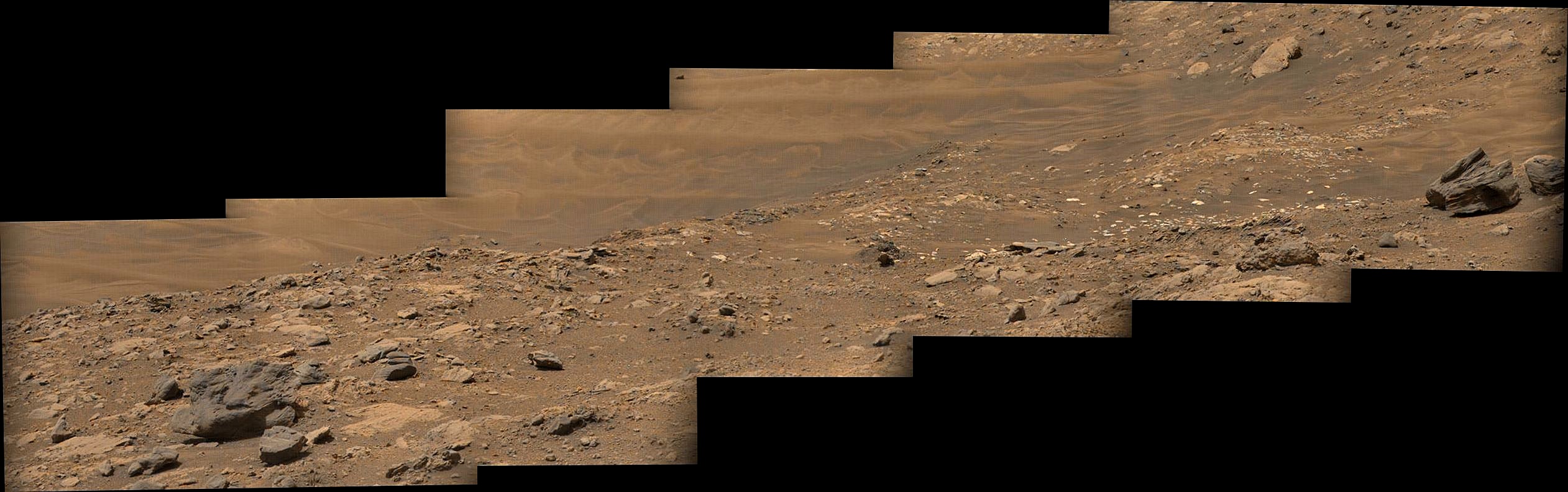
Roughly assembled from 15 overlapping Bayer reconstructed L-MastCam images. Looks like the rover basically repositioned on the same piece of bedrock (sol 4293) so they could reach certain targets with the instruments and tools on the robotic arm